Map of Edge Hill
Resource Type: Image | Posted on 10th May 2011 by Jenny Porter
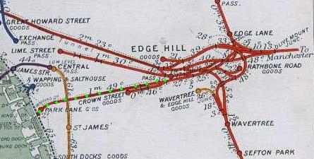
This map shows Edge Hill and the surrounding area, including other stations such as Lime Street, Central, Crown Street and Park Lane. Various goods yards are shown, as are the Olive Mount Junction and the Wapping Tunnel. Wapping Tunnel was built to allow goods services to operate on the Liverpool and Manchester Railway, and was the first tunnel in the world to be built under a metropolis, and the second (after Crown Street) to be built under streets. It runs from Edge Hill cutting to the now-defunct Park Lane goods station near the docks. Originally, it was proposed that the Railway should run north along the docks, but local landowners objected, so a new route had to be chosen, on a 1 in 48 gradient - much too steep for the locomotives used at the time. Thus, in addition to the much longer Wapping Tunnel, a stationary engine was installed in Edge Hill cutting in a short tunnel near the Moorish Arch to haul trucks by rope from Park Lane, enabling them to be connected to locomotives at Edge Hill, to be taken to Manchester. The Tunnel closed in 1972, the same year as Park Lane. At the docks end, it splits into three: the original 1829 tunnel into Crown Street on the right, the portal in the middle, and an 1846 tunnel to the Crown Street goods yard on the left: the latter is still in use as a headshunt and as a locomotive run-round for goods trains.
Categorised under: The Station & Railway Pioneers
Comments